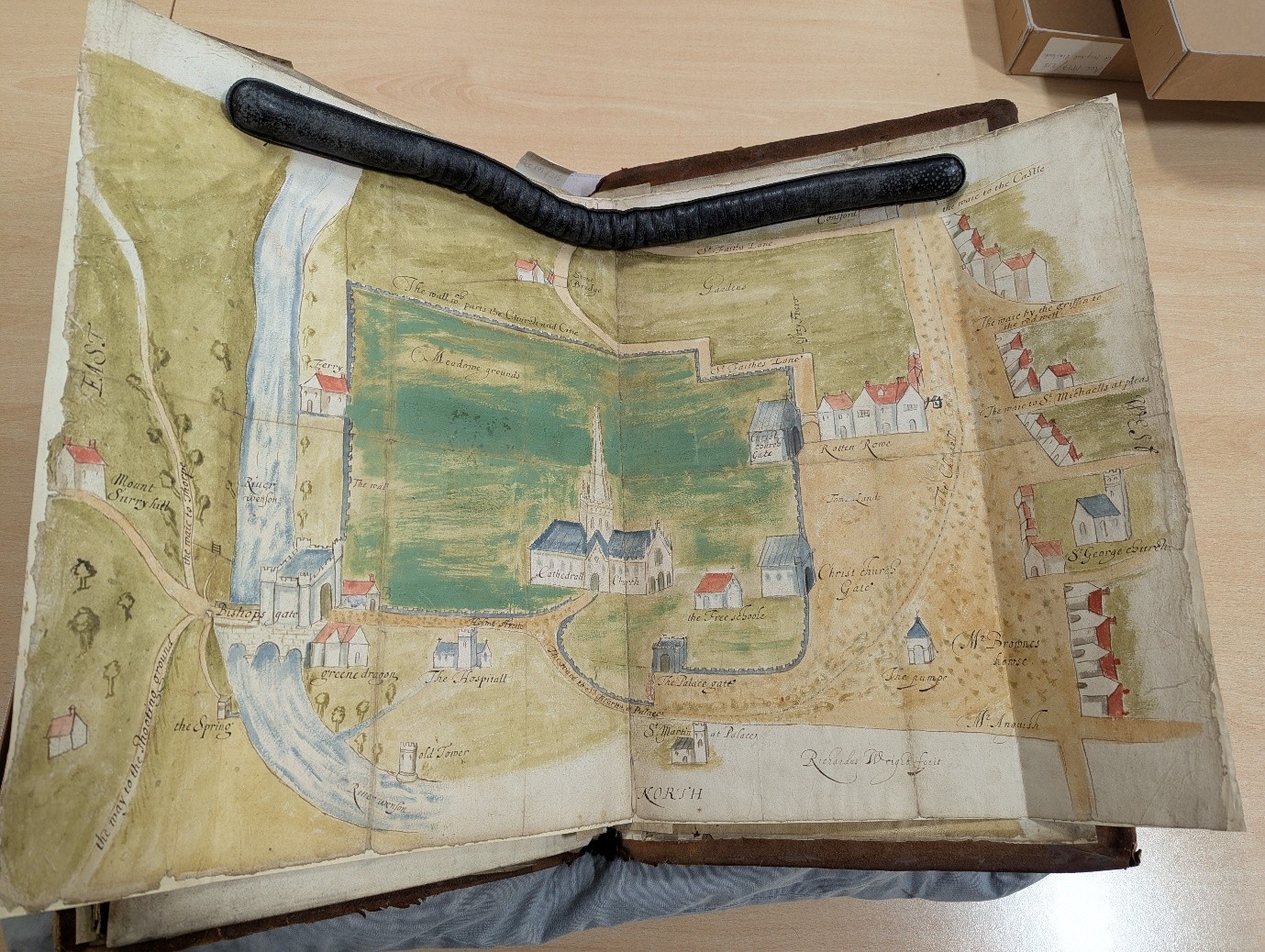
This post started as an exploration of the changes to Tombland that have occurred between the 1630s production of Richard Wright’s map of Norwich and the modern day. However, as I came to learn more about the story surrounding this map, my focus quickly shifted. As we will see, not every difference between this map and maps of Norwich today are due to new buildings and roads, but rather what the people commissioning the map chose to include. This map tells a story about the people who produced it and the social conflicts they witnessed.
What the Map Shows
The map details the boundary between land under the jurisdiction of Norwich Cathedral and the City of Norwich County Corporation. The “Channell” in the centre acts as something of a dividing line between the two areas. The Eastern part of the map shows a very different picture of Norwich to what is here today. Landscape features such as “the way to the hunting grounds” and the presence of decorative trees hint at an area of managed countryside which could have been used by the City’s elites. As we move west, we see several familiar features in more archaic forms. The site of the Bishopsgate Bridge is depicted with its now demolished gatehouse and in the site of the modern-day Red Lion pub, we see an older establishment called the Greene Dragon. Moving further west still, we see the first obvious piece of omission that is present on this map; there is seemingly no Adam and Eve pub. Moving into Tombland itself, we see the depiction of “the pumpe” on the site of the water fountain constructed in the 1800s and the residences of some of the wealthier merchants of Norwich, such as “Mr [Alexander] Anguish” and “Mr [William] Brown” – both former mayors of Norwich between 1629-31. The centre of the map is occupied by the Cathedral enclosure itself. Within this area is “the Free schoole” – a grammar school managed by the Corporation in charge of providing poor relief and education. Just outside Ethelbert gate, marked as a “Christ Church Gate”, is the noteworthy “Rotten Rowe” (often referred to as Ratton Rowe). This was the site of a pub called the Popinjay.
Read more: An exploration of 17th Century TomblandThe Omissions
As previously mentioned, the map deliberately omits a number of buildings that are known to have existed in Norwich at the time. Importantly, less detail is afforded to areas that are under the jurisdiction of the Cathedral. Many of the houses on Holme Street, the way to St Martin at Palace and within the Close itself are now shown on the map as they were managed by the Cathedral at this point. The numerous pubs (both licenced and unlicenced) and shops that existed within the Close add to these omissions.1 All of these sites became focal points of tension between the Corporation and Cathedral, with the former often claiming that the latter did a poor job of maintaining an acceptable moral level of behaviour. The Cathedral’s inability to provide effective poor relief, education and healthcare following the reformation became a further source of tension.2 Reasoning behind these omissions can be hard to identify without clear knowledge of who commissioned the map. If the map was commissioned by members of the corporation of Norwich, it could reflect a lack of interest in the holdings of the land held by the Cathedral. However, if the work was a commission by the Cathedral itself, it’s possible that the omissions relate to a desire to present the Cathedral as a more orderly location suitable for the more orthodox type of worship promoted by figures such as Archbishop Wren. However, as we don’t know who originally commissioned the map, much is down to speculation and interpretation.
Who originally commissioned the map?
The answer to this question is likely to be lost to time. However, there are some features that hint at who the commissioner was. The handwriting present in the map is strikingly similar to labelled drawings of the cathedral from the 1630s labelling where the mayor should sit during a church service.3 Whilst this does not necessarily mean that the works were created by the same person, it could mean that the hand that labelled them was the same. This may suggest that they were originally part of the same collection of documents. However, it is also important to note that scribes of this period would often accept private commissions for their services. The maps mention of Alexander Anguish and William Browne provides a more useful hint in providing an answer as to who may have commissioned it and when it was commissioned. The visibility of the walls of the Cathedral that might have been obscured by buildings within the close is also a hint. Between 1632-3, we see a land dispute between the Corporation and the Cathedral being concluded by the presence of the Cathedral’s wall. It claimed that all land falling outside of the walls would become the jurisdiction of the Corporation.4 With this additional knowledge, the conclusion that the map is stating that all land within the Cathedral walls is that of the Cathedral and all outside the Cathedral walls is that of the Corporation seems very likely. It is important to note that at the time that Alexander Anguish and William Browne were mayor this conclusion had not been reached. However, the depiction of sites such as the Popinjay on Ratton Rowe indicates that their intention at this point is clear.
Researched and written by Michael Palmer
- R. Houlbrooke. “Refoundation and Reformation” in eds. I Atherton, E. Fernie, C. Harper-Bill and H. Smith. Norwich Cathedral: Church, City and Diocese, 1096-1996. (London: The Hambledon Press, 1996). Pg. 525 ↩︎
- Ibid. Pg. 537 ↩︎
- Unknown Artist. Norwich Cathedral Choir. 1630. Drawing. Norfolk Museum Collections. Norwich. ↩︎
- Decision of lord chancellor in dispute between city and cathedral re jurisdiction. 1633. NRO, DCN 89/20. ↩︎