Written by Leslie Eddowes for the Hall Marks project
Background
This is an account of my search to find the exact site of the original hall at Crown Point. Along the way I collected a ruined hall, a lost hall and a hall which still stands, but whose size, purpose and name have all changed since it was built.
Introduction
I am a volunteer at Whitlingham Country Park, a popular 284-acre free-to-access green space, to the south of Norwich. The park occupies part of the Crown Point Estate and is managed by Whitlingham Charitable Trust.
The name ‘Crown Point’ originates with a house built for John Money (1740-1817) who later became General John Money.[1] Money’s estate is marked on Faden’s Map of Norfolk (1797) with a pictogram of the hall and ‘Money Esq.’ printed alongside (Figure 1).
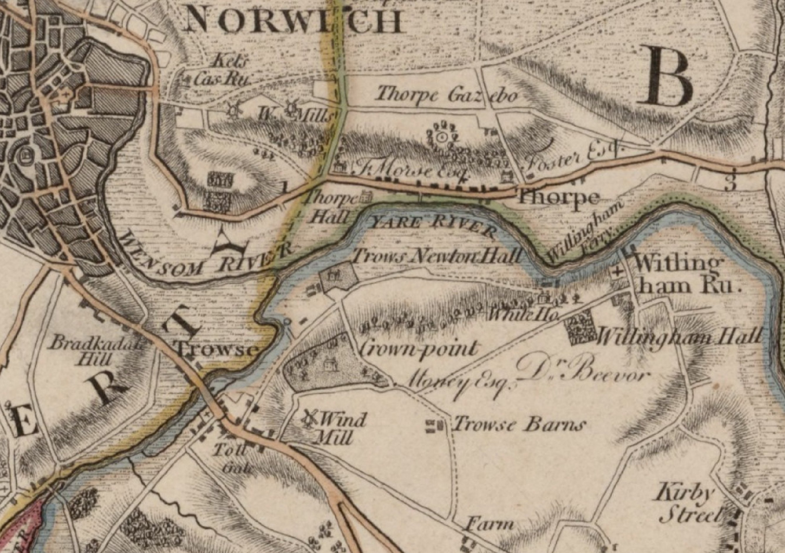
Figure 1. Extract from Faden’s Map of Norfolk (1797) showing part of John Money’s Crown Point estate. Reproduced with the permission of the National Library of Scotland.
While Faden’s Map of Norfolk may have been the most detailed map of the county to date, it was not sufficiently detailed that the exact position Money’s house can be deduced from it.
The old and new Crown Point Houses
In his survey of Norfolk country houses, published in 1961, Basil Cozens-Hardy wrote:
‘Crown Point, which in effect became the hall, was first erected in 1784 by General Money of aeronautical fame. …R. H. Harvey pulled down this house and built another mansion near its site and soon afterwards committed suicide there, causing some consternation in local banking circles.‘[2]
Surrounded by other diverting details, the phrase ‘near its site’ stood out. It suggested I would not have to search too far from Sir Robert Harvey’s mansion, which still stands. It is now a Grade II* listed building whose official description states, ‘It was built during the 1860s to replace an earlier Crown Point House, on a different site.’[3]
A ruined hall
It was while searching for images that might give a clue to the location of Money’s Crown Point that I came across an oil painting by Thomas Bardwell (1704-1767). It is entitled ‘A prospect of Trowse Hall, Norwich’ and was evidently composed from a situation close to the location of Harvey’s Crown Point (Figure 2). Bardwell died 17 years before Money’s Crown Point was built, but perhaps there were clues in his picture?
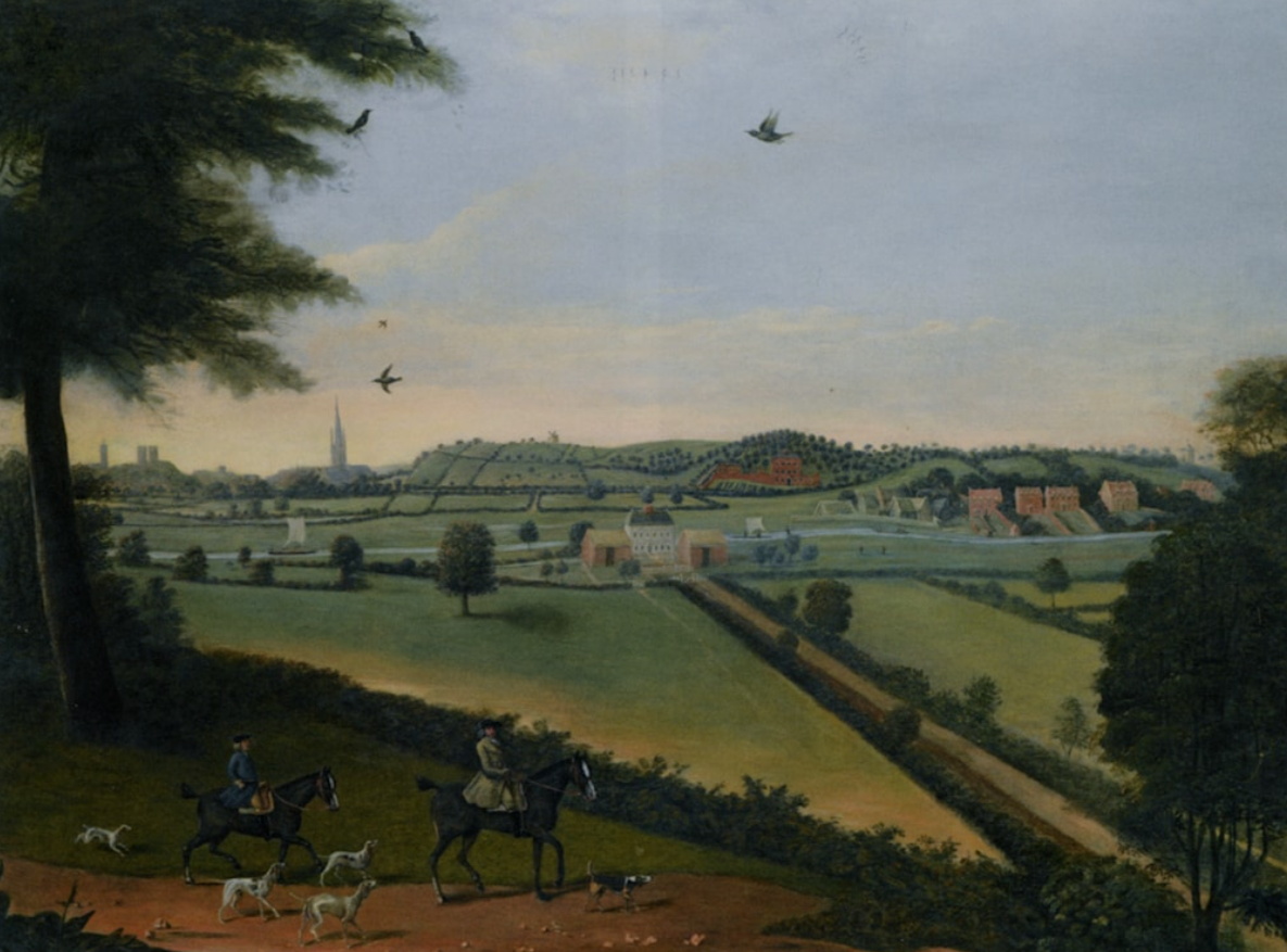
Figure 2. A prospect of Trowse Hall, by Thomas Bardwell (1704-1767).
Bardwell’s painting depicts an historic landscape. Some features are familiar, including the silhouettes of Norwich Cathedral and Norwich Castle on the horizon and the depiction of the River Yare flowing west to east. Other aspects are novel. A hedge-lined avenue, for example, leads directly to Trowse Newton Hall, which is shown complete.
Trowse Newton Hall was built for the priors of Norwich Cathedral and demolished in the 1860s. According to Cozens-Hardy, Harvey, who acquired the estate in 1861 ‘…ruinated the building on the idea that no considerable property should be without a ruin.’
The riders and dogs surveying the scene emerge from a track that no longer exists. Could this be a clue – where did it lead?
Spot the difference
Three other images of buildings labelled ‘Crown Point’ came to light courtesy of Norfolk Museums.[4],[5] Two clearly depict Harvey’s Crown Point (Figure 3).
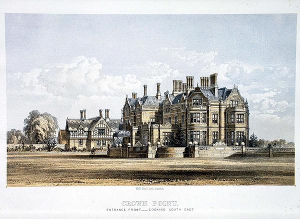
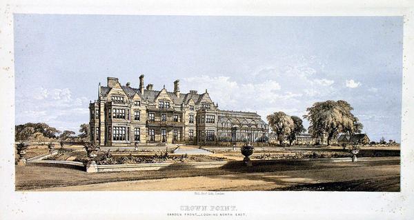
Figure 3. Views of Crown Point House, Whitlingham. Left: front. Right: looking southeast. © Norwich Castle Museum & Art Gallery, Norfolk Museum Service.
A third undated lithograph labelled ‘?Crown [sic] Point House, with tents pitched in garden’ shows a very different building (Figure 4). [6] Presumably this was Money’s Crown Point?
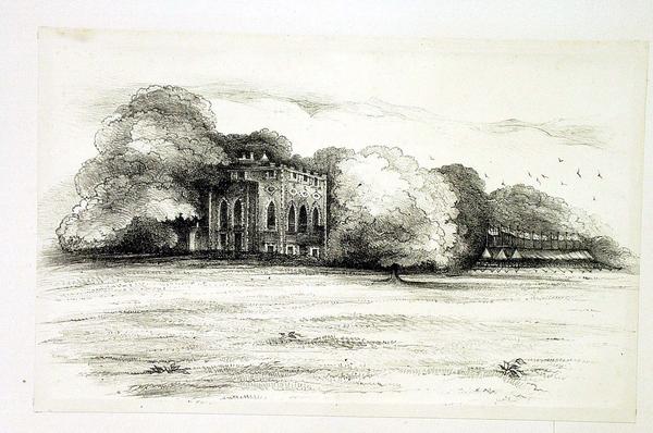
Figure 4. Crown Point House, undated lithograph. © Norwich Castle Museum & Art Gallery, Norfolk Museum Service.
Unfortunately, the image does not reveal much about its location, except that it appears on a slight eminence enveloped with trees. The substantial tents with numerous flags were an unusual feature.
Hall Marks
It was at this point that I became aware of the Hall Marks project at Norfolk Record Office. Their officers assisted me by highlighting documents and images I had not found before. One of these was an account in the Illustrated London News which appeared to explain the presence of tents next to Money’s Crown Point (in Figure 4). The article appeared on 27 September 1862, after Mr Harvey had acquired the site, but before he had built the new house.
Under the headline, ‘Great volunteer fete at Crown Point’, the article explained Harvey had wanted to mark his year in office as High Sheriff of Norfolk by hosting a memorable event.[7]
‘The volunteer force of the county … were invited to a review in his grounds, and the whole of the local public were invited to go and see them.’
‘A series of tents formed one monster canvas inclosure, 260ft. by 150ft., in which dining accommodation was provided for the whole of the men bearing arms and about 2300 ladies and gentlemen. The predominating colours which distinguished the whole – red, white and blue – gave the scene a very pleasant effect.’
The article was accompanied by two illustrations that demonstrated the scale of the celebrations (Figure 5).
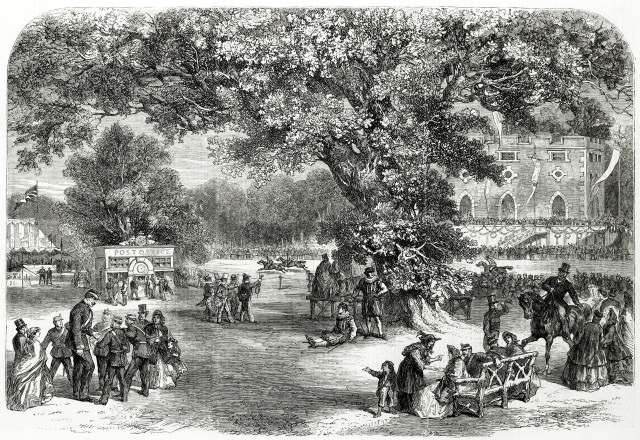
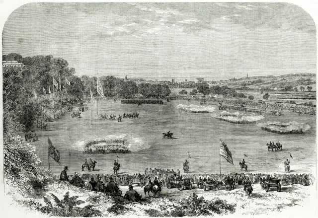
Figure 5. Volunteer fete given by Mr Harvey at Crown Point near Norwich, 1862. © Illustrated London News/Mary Evans Picture Library.
One of these depicted a building like the Crown Point House shown in the lithograph (compare Figure 4 and ).
Another document was a Red Book, created by the landscape gardener Humphry Repton (1752-1818), for Philip Meadows Martineau. It contains a view from the perspective of a new villa being built for Martineau at Bracondale, that looks out over the River Yare toward Trowse, near Norwich ([8]).
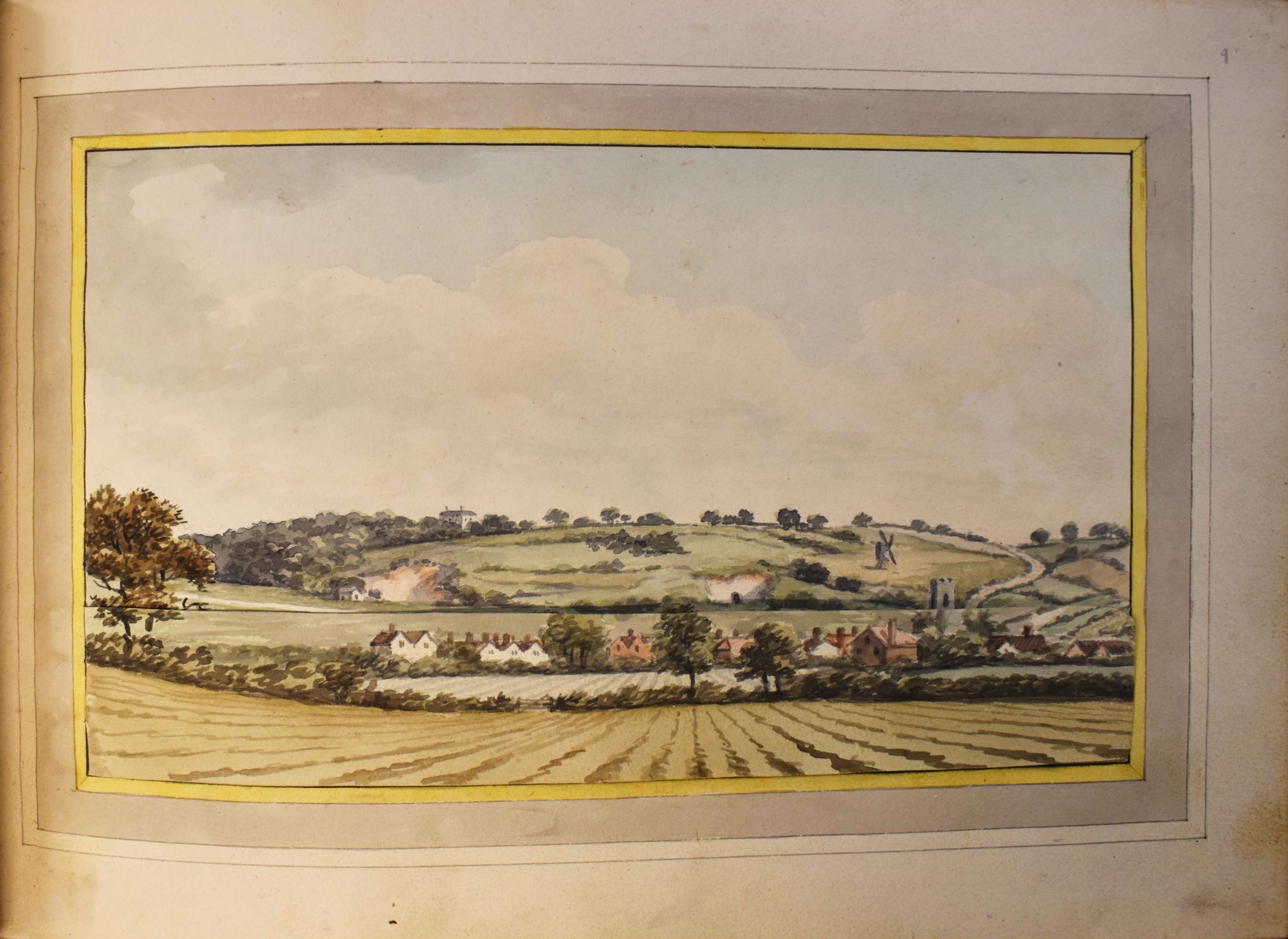
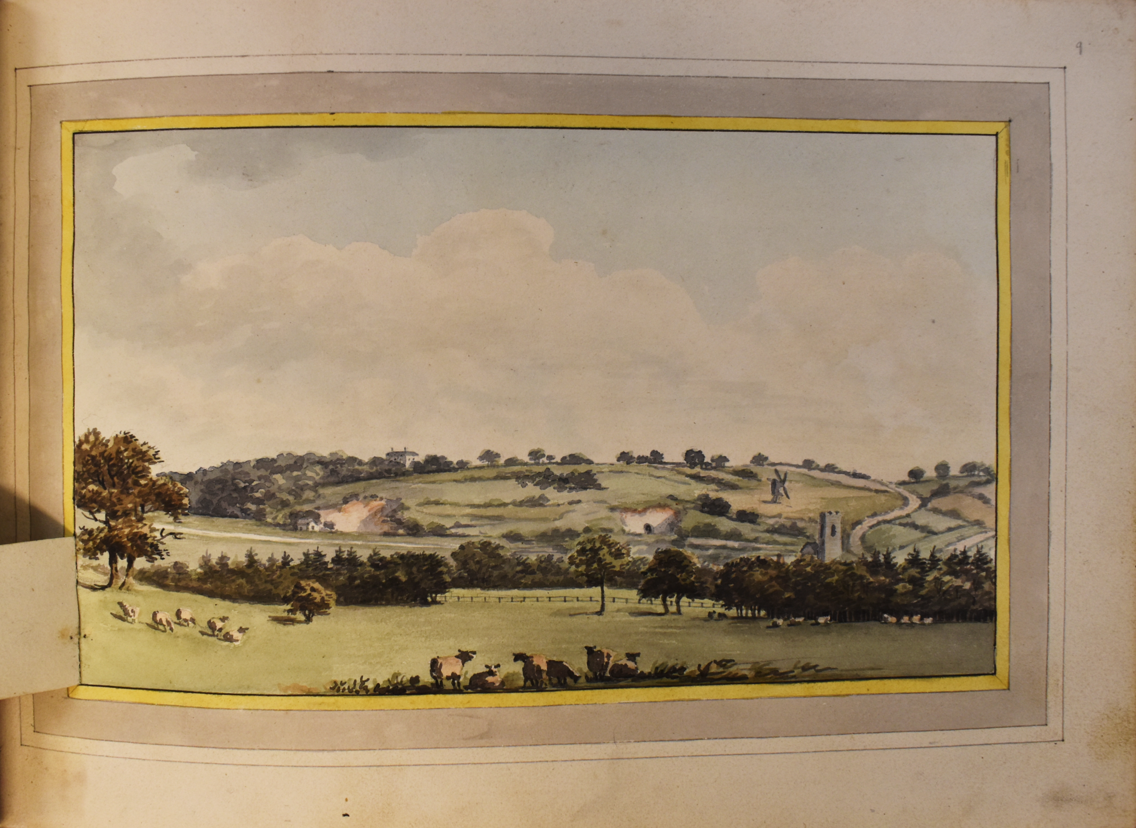
Figure 6. View over Trowse (showing the scene ‘before’ and ‘after’). Watercolour by Humphry Repton (1752-1818).
The Red Book was prepared after Money’s Crown Point was built and before Harvey’s building was constructed. Repton’s image also shows St Andrew’s Church in Trowse and Trowse Post Mill (the latter was destroyed by a gale in 1845).[9] Therefore, the prominent building on the horizon must represent Money’s Crown Point.
I wondered whether a triangulation exercise involving these landmarks, in association with the other images I had found, would help me achieve my aim of identifying the exact site of the hall. Before I had chance to find out, I was directed to the Norfolk Historic Maps website.
Maps, maps, maps
The Norfolk Historic Maps website is being updated and will be relaunched as part of the Hall Marks project. It currently contains five layers of historic maps, one of which consists of a collection of Norfolk Tithe Maps. It is currently incomplete, but it was my good fortune that the Tithe Map for Trowse, drawn-up in 1844 was already included.[10] Marked upon it, unmistakably, was a square black silhouette representing the footprint of Money’s Crown Point.
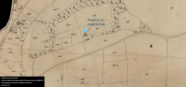
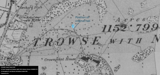
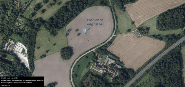
Figure 7. Tithe Map, Trowse (1844), NRO DN/TA 841.
The first edition Ordnance Survey map of the same area produced between 1879-86 does not show this feature. Instead, Harvey’s ‘Crown Point House’ is clearly marked a short distance to the south-east.
Crown Point pin-pointed
Cross-referencing the two maps, and comparing them with modern imagery, the site of Money’s Crown Point House can now be identified within an arable field immediately north of Harvey’s hall (Grid ref TG 2538 0716. Lat 52.6155°N Long 001.3279°E). LIDAR images of the area suggest the hall has left no trace of its existence.
The later Crown Point Hall was built for Sir Robert Harvey in 1865. It was acquired by the Colman family in 1872 following Sir Harvey’s suicide in 1870. It was extended and enlarged in the 1900s. The building was later used as Whitlingham Hospital.[11] It has since been converted to private apartments and renamed Whitlingham Hall.
Acknowledgements
I am grateful for the help provided by the Archaeology Department and Dr Fiona Savage of the Art Department at Norfolk Museums Service. Also, I am grateful to Dr Andrew Tullett of the Hall Marks project whose encouragement, support and guidance was central to finding the exact site of the original Crown Point House.
Every effort has been made to trace copyright holders. We would be pleased to rectify any omissions by updating this blog should they be drawn to our attention.
[1] White’s Directory for Norfolk (1845) on GENUKI: Norfolk: Trowse Newton, Norfolk.
[2] Cozens-Hardy, B. (1961). Some Norfolk Halls. Norfolk Archaeology 32, pp. 163-208.
[3] Historic England. List entry 1373212: Whitlingham Hospital Blocks 04, 05, 06, on https://historicengland.org.uk/listing/the-list/list-entry/1373212
[4] Crown Point House, Whitlingham. Front-looking southeast. Lithograph on paper. Accession Number NWHCM : 1954.138.Todd11.Henstede.48 on https://www.museumscollections.norfolk.gov.uk/
[5] Crown Point, Garden Front. Looking North East. Lithograph on paper. Accession Number NWHCM : 1954.138.Todd11.Henstede.47 on https://www.museumscollections.norfolk.gov.uk/
[6] ?Crown Point House, with tents pitched in garden. Undated lithograph on paper. Accession Number NWHCM : 1954.138.Todd11.Henstede.49 on https://www.museumscollections.norfolk.gov.uk/
[7] Illustrated London News, Saturday 27 September 1862. Great volunteer fete at Crown Point, Norfolk. Pages 328-329 and 354-355. Retrieved from the British Newspaper Archive.
[8] Repton, Humphry (1752-1818). Bracondale: a villa of Philip Martineau. Reference copy at Norfolk Heritage Centre, BRN: 596736
[9] Norfolk Mills – Trowse post windmill
[10] Tithe Map, Trowse (1844), NRO DN/TA 841.
[11] Norfolk Heritage Explorer, https://www.heritage.norfolk.gov.uk/record-details?MNF9696