
Before I wrote off my last motorbike and became an ex-biker, I frequently enjoyed cruising on my Harleys along certain sections of the A47 and A10, where, to my fascination, my head seemed to be below the level of the river alongside. The waterway had obviously been straightened and embanked at some stage, and of course, I had heard of Cornelius Vermuyden, but I had no idea of the vastness of the project of which this was part until I researched in Hall Book (KLBA, KL/C 7/13), which covers the years 1731-81.
It was in this Hall Book that I noticed a reference to the Durham Memorial, and my curiosity was aroused. The Durham Memorial refers to a scheme to improve navigation on the River Wear.
In his book The History of Britain in Maps, Philip Parker[1] includes the 1769 Stockton to Darlington Canal Map. As he says,
“Cotton, Coal, Steel and Steam were the quartet which drove Britain’s Industrial Revolution…….commodities which were difficult and expensive to transport by road…. An obvious alternative was by water, but many of Britain’s waterways were either not fully navigable along their entire routes, or did not link with others, making it impractical to use water transportation except in particular circumstances or for short distances.”
As indicated above, that map was published in 1769, but reference to Hall Book (KLBA, KL/C 7/13) shows that similar schemes had already been in process locally for many years. Coal was already a vital resource that was passing through King’s Lynn, as seen in various Borough accounting records (KLBA, KL/C 44).
On 29/11/1742 there had been recorded a petition to Parliament for the preservation of the harbour:
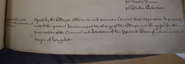
Minute about the Petition to Parliament from the King’s Lynn Hall Book, 1731-61. KLBA, KL/C 7/13
In the same year, a committee was set up to go with the Corporation of Adventurers of the Bedford Levels, a body with the finances and expertise for major undertakings, to Ely.
The Adventurers’ history begins in 1663, when the Bedford Level Corporation was founded to manage draining the Fens. Thence followed formalisation of the status of the Company of Adventurers, a body set up by the Earl of Bedford, with the aim of reclaiming 95,000 acres of the Bedford Level. Such work had previously been undertaken by the great monasteries, but fell into neglect after the Dissolution. Things got so bad by the 1600s that Charles I commissioned the Dutch engineer Cornelius Vermuyden to come up with a solution. In 1630, the Earl of Bedford, who owned most of the land, accepted a contract to do the job, instead of it going to Vermuyden. It was known as the Lynn Law, as it was drawn up in King’s Lynn. Bedford and 12 associates, the Adventurers (or venture capitalists) allocated shares in the scheme amongst themselves. It was a somewhat chequered story, and in 1638 the King revoked the contract, taking charge himself, and asking Vermuyden to manage the project. Work was interrupted by the Civil War, but resumed in 1649, supported by what was known as the Pretended Act, and the later General Drainage Act. Drainage caused the land levels to sink, and it was necessary to install pumps, of which more later, to lift water into the drainage channels from the surrounding fields. In 1843 the Adventurers moved their HQ to Ely, until finally it was wound up and responsibility passed to the Ouse Drainage Board, which in 1930 became part of the River Great Ouse Catchment Board.
But to return to the main thread of our story, a committee was set up to work with the Adventurers:
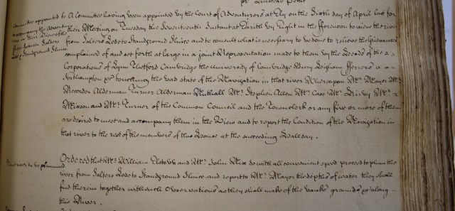
Committee set up to work with the Adventurers in the King’s Lynn Hall Book, 1731-61. KLBA, KL/C 7/13
and on 2/5/1743, they were at Salter’s Lode. Soon after that, an order was made to improve navigation as far as Whittlesea.
On 17/5/1746, the Council made representation to the Adventurers about the creation of a new sluice at Denver. The Corporation feared the potential silting, which would, in their words, destroy the navigation to the port.
An order by the Court of Adventurers in Wisbech was recorded in the Hall Book on 8/7/1752 concerning the navigation of the River Nene between King’s Lynn and Wisbech. It called for funding for an Act of Parliament to help the better navigation of the river to give a general benefit to trade.
A plan, running to 15 clauses was presented. These clauses are concerned predominantly with the constitution of the commission, where and when regular meetings should be held, and in which journals they should be publicised. As far as practicalities are concerned, they specified the building of gates to keep salt water out of the improved navigation, the widening, straightening and deepening of the navigation, and the raising of tolls to finance the work. Additionally, it was now prohibited for landowners alongside the river to take water out of it without written permission. The reason is obvious- a certain depth had to be maintained for navigation- but it must have caused resentment among those who had previously regarded the river as a common resource. Mention was made above of wind driven pumps for draining the Fens into the river; in the Plan, they are referred to as tongs, a term which I cannot find anywhere else.
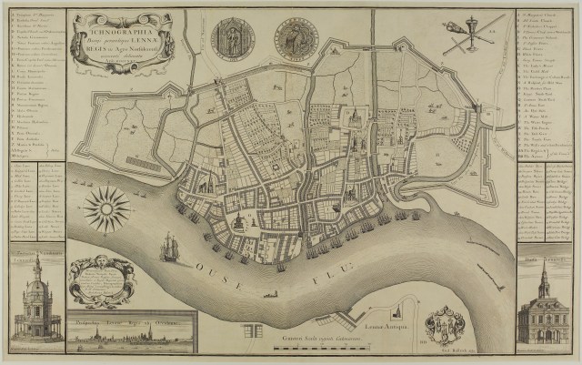
Plan of King’s Lynn and the River Ouse by William Rastrick, 1724 (NRO, BL 4/1)
The Adventurers became involved again, and presented an alternative plan, to which the Council responded. The Adventurers’ plan differed primarily from the Council’s plan in the administrative side- the commissioners, meetings, publicity and finance. It was as much as anything else a power struggle.
The plan was read in Council on 9/4/1753. A final Plan was, essentially, a compromise between the two.
On 16/5/1753, a committee was appointed, including representatives of the Adventurers, “to agree upon a plan for an Act of Parliament for improving the navigation of the Nene”, following on from the 1752 proposal. This was followed on 12/7/1753 by the Bedford Level Court session held at the Crown Inn, Huntingdon.
On 8/8/1753, a committee was appointed for measuring coal imports, after a new coal measure had arrived from the Commissioners of the Customs. New mets (a measure of weight) were ordered and old mets were only to be used until their replacements had been delivered.
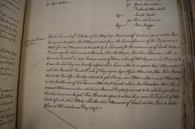
Information about measuring coals from the King’s Lynn Hall Book, 1731-61. KLBA, KL/C 7/13
Robert Walpole, MP for King’s Lynn from 1702 to 1738, was also involved, writing to the Mayor on 26/1/1754 concerning coal and the Act before Parliament regarding the navigation of the Nene.
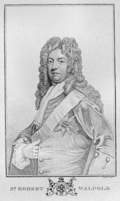
Portrait of Robert Walpole from King’s Lynn Town Hall
Navigation of the waterways further up river can been seen in 11/3/1757, when a reference was made to a Bill for the navigation of the river Ivel, a tributary of the Ouse in Bedford, from Tempsford to ‘distant places’. This was followed by the incentive that the project, “will greatly extend the trade of King’s Lynn”, and, presumably, the income from the tolls.
All this throws light on what otherwise might seem irrelevant- the introduction in Council of the Durham Memorial, which is then explained in detail.
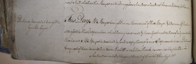
Information about the Durham Memorial from the King’s Lynn Hall Book, 1731-61. KLBA, KL/C 7/13
The Durham Memorial, as indicated above, refers to a scheme to make the River Wear navigable from Durham to Sunderland, referring to the Act of 1746, and complaining that “not one farthing has been paid out despite an order to do so by midsummer 1759”. So, it seems they sought help from other potentially interested parties in an effort to get the scheme moving.
A letter was received from Durham Council to King’s Lynn on 25/1/1759. Durham was seeking the support of King’s Lynn in Parliament for their petition for the scheme, pointing out that making the Wear navigable would be, “of great benefit to the trade, industry and people of Norfolk, Suffolk, Cambridgeshire, Huntingdonshire, Hertfordshire, Hertfordshire, Northamptonshire, Bedfordshire, Rutland, Buckinghamshire, Lincolnshire and Leicestershire.”. The list of counties demonstrates the reach of the waterway systems into the heart of the country and the importance of navigable waterways.
King’s Lynn replied, presenting a petition of support on 23/3/1759. It was all about coal, easing transportation from the Durham coalfields to the port of Sunderland, thence by sea to King’s Lynn, which would, ipso facto, be the onward transportation hub to the West Midlands, with import tolls adding to the wealth of the town.
Sadly, though, this great scheme was not good news for everyone. My family name was recorded in Norfolk parish registers from 1538, when the registers were made a legal requirement, and in other documents before that. They arrived in Norwich in 1672, and in the decades that followed, many of them became Freemen of the City. But they were mainly weavers and cordwainers (The Worshipful Company of Cordwainers defines cordwainers as “shoemakers, originally highly skilled craftsmen who used the finest goatskin leather from Cordoba in Spain.”). In the 1860s, along with many others from East Anglia, they found that the Industrial Revolution brought an end to regional, home-based industries such as theirs, and found it necessary to move to the North. In my family’s case, the destination was the West Riding of Yorkshire, mainly Bradford and Halifax.
It’s not all bad, though- they moved from one God’s Own Country to another. And when my career brought me in a roundabout way from Bradford to Norfolk, I found myself living just five miles from where my family originated. It really was a case of coming back to roots.
Researched and compiled by Pete Widdows
[1] Parker, P. History of Britain in Maps, Collins (2017)


I have always been fascinated by the fens, as my grandparents lived in Tilney and we sometimes ventured out as far as Wisbech and Peterborough when I was a child. My son and his wife now live in Peterborough and my respect for the engineers grows with every one of our drives over that way. The tiny marsh-man’s cottage is crying out to be looked after and I’d love to demolish all those buildings around it, to give it back its real place in the landscape.
The development of King’s Lynn and its relationship with the water is fascinating too. The realignment of the river and the filling in of the fleets are well worth looking into. I have an ongoing project, looking at The Purfleet and I’m hoping to publish a book in the next few years.
The filling in of the Middle Stop Drain from Friar’s Fleet is very sad as that was a very picturesque area.
Reminiscing! Must mean I’m getting old!
LikeLike
Thank you- it’s great to hear some reminiscences about the area and it’s history with the river.
LikeLike
Thank you- we’ll pass your comments on to our blogger
LikeLike
A wonderfully readable post. Thank you.
LikeLike
Pingback: King’s Lynn’s burning issue | Norfolk Record Office