I have recently been cataloguing a run of maps from the list of uncatalogued material here in King’s Lynn Borough Archives. Out of this series of eight maps one was the King’s Lynn Bomb Map (NRO, KL/SE 3/8). It was transferred to King’s Lynn Borough Archives from the Planning Department of the Borough Council of King’s Lynn and West Norfolk on 11 January 2002. It is similar to the Norwich bomb map which has been the subject of recent conservation work. However it appears that the Lynn map has seen less use and display over the years, and so is still in reasonable condition.
King’s Lynn Bomb Map
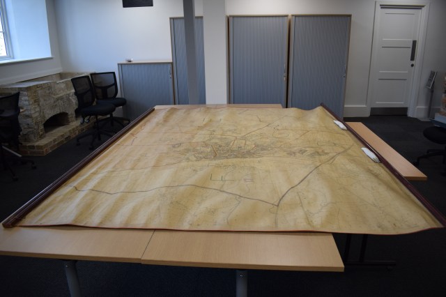
The map is very large at 200cm high and 275cm wide. It is fixed to a wooden support at the top edge and has a smaller wooden weight at the bottom. It would likely have been displayed vertically hung on a wall when not in storage. It is made out of nine Ordinance Survey map pieces which have been stuck together. These maps date from either 1928 or 1929. Later housing developments have been stuck onto the map.
In September 1940 the government started to collect and collate information relating to damage sustained during bombing raids. Information was initially collected on London, Birmingham and Liverpool but by September 1941 the ‘bomb census’ had been extended to cover the rest of the UK. The purpose of the bomb census was to collect a complete picture as possible of air raid patterns, types of weapons used and the damaged caused by them. Particular attention was paid to strategic sites such as railways, shipyards and factories. The UK was divided into 12 civil defence regions, with King’s Lynn being covered by the Eastern Region which had its headquarters in Cambridge. Reports of damage collected by the police and local air raid wardens were sent to the Ministry of Home Security and collated.[1]
Unlike the Norwich map the bomb location pins are no longer in place. Instead there are a series of colour coded dots. Blue indicates a high-explosive bomb while orange represents an incendiary device. The town, and the surrounding area, are divided into numbered sections.
You can see the location of the bomb that hit the Eagle Hotel on Norfolk Street on the night of June 12th 1942 which killed 42 people. The single dot is just visible on the boundary line, above the ‘k’ in Norfolk Street. Some air raids were followed up with more detailed investigations. The June 12th bombing was one such event. The files of which can be seen, along with others, at the National Archives in Kew (TNA, HO 192/207).
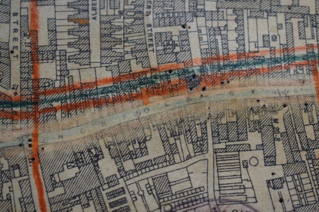
Pin marks showing the location of the bomb on the Eagle Hotel, Norfolk Street
King’s Lynn was not heavily bombed during the Second World War. Less than a hundred bombs were dropped on the town over the duration of the war. Upon closer inspection there are pin marks all over the map. This is especially evident when looking at the reverse side of the map while unrolling it. Unlike the pins that note where the bombs landed these holes are not all in straight lines. Instead many are in seemingly random patterns. It is possible that the map was used for other projects after the war.
Due to the size of the bomb map researchers are requested to make an appointment to view it. This can be done by emailing norfrec@norfolk.gov.uk
[1] Information from the National Archives website. Accessed 23/05/2017 [http://www.nationalarchives.gov.uk/help-with-your-research/research-guides/bomb-census-survey-records-1940-1945/]