
When cartographers surveyed Norfolk in the 16th century, the landscape they mapped was very different to the one we see today. Many visitors to the Norfolk Record Office enjoy seeing how Norfolk has changed over the centuries and thanks to the map collection of Raymond Frostick, the public can see how the county’s geography developed over a 300 year period.
The Frostick Collection was donated to the Norfolk Record Office in 2013, by former Lord Mayor of Norwich, Raymond Frostick. The collection contains more than 150 maps dating between 1574 and 1840, and gives an interesting insight into Norfolk’s history. Through the collection, advances in mapping techniques can be seen, including extremely rare prints and unusual formats.
The earliest map in the collection was produced by Christopher Saxton in 1574 and is believed to be the first map of any English county. It shows settlements, churches and rivers but roads were not added until later copies, reproduced from the same engraved copper plate in the 17th century. The area to the west of King’s Lynn is described as “Mershe Lande” and shows several unfamiliar rivers which were diverted long ago due to drainage of the Fens. The population of Norfolk at the time was quite high, compared to other areas of the country, and measurements for the map would have been taken from church towers.
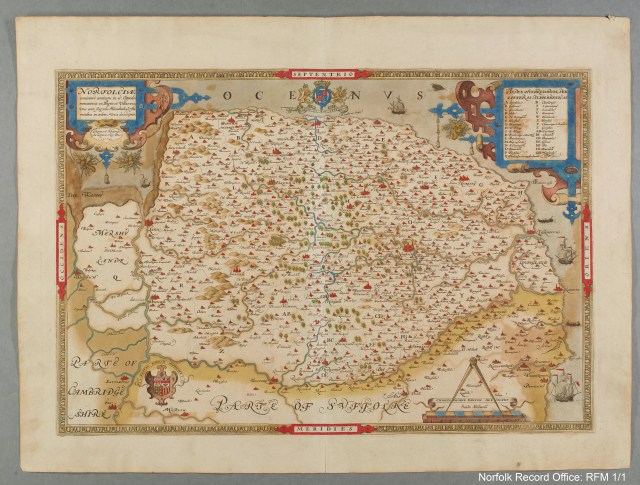
Christopher Saxton’s map of 1754. This provided the basis for almost all maps of the county until the end of the 17th century. Norfolk Record Office: RFM 1/1
The Norfolk map was one of 34 maps of the English and Welsh counties, published in An Atlas of England and Wales by Christopher Saxton, London, 1579. It was also sold as an individual sheet. Saxton’s map was the precedent for most of the maps of Norfolk during the 17th century and was still being published late in the 18th century.
The Raymond Frostick Map Collection
The maps in the Frostick Collection are an invaluable primary record of the landscape and urban history of Norfolk. They can give us an idea of the lie of the land, of how the coast has changed and how the suburbs of Norwich have grown. As the collection is so large, it is also possible to compare how surveying and mapping techniques developed over the centuries. On the earliest maps, the locations of Norfolk towns and villages can be pinpointed by their church towers.
Maps by Dutch and Flemish cartographers are also included in the collection, demonstrating the significance of the trading relationship between Norfolk and the Low Countries. There are examples of road maps and rare maps, including some unusual examples in the form of playing cards. These maps often contain information about the county depicted. For example, William Redmayne’s six of spades card of 1676 describes Norfolk as the following:
“NORTHFOLK- Is bounded with Suffolk, on the East & on the North with the Germaine Ocean, and on the West with the River Ouse. Its Rich of Sheep, especially Cunnies [rabbits], Store of Wood, its Soyle is various, fat and Rich, Clayey and Chalkey. Norwich Citty is famous, almost Intrencht with Water, on the West ther’s a draw-bridg, on the other side the Ocean. It hath 27 Market Towns, 525 Villages and 660 Parish Churches. Its greatest Gaynes are by Herrings”.

A map of Norfolk on a William Redmayne playing card, 1676. The Redmayne Cards were regularly advertised for many years. NRO: RFM 1/20/2, 1031×1
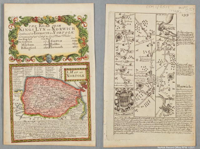
A map engraved by Emanuel Bowen for Britannia Depicta, 1720. The front depicts the road from King’s Lynn to Great Yarmouth and the reverse, the road from Ipswich to Harwich. NRO: RFM 1/25/1, 1031X1
Mr Frostick was Lord Mayor of Norwich in 1976-1977 and chairman of Norfolk County Council in 1983-1984. He has published several books on historical maps including ‘The Printed Maps of Norfolk 1574-1840 A Carto-Bibliography’, which can be found in the reference section of the Norfolk Record Office Searchroom. Digital copies of the Raymond Frostick Map Collection can also be accessed on a computer in the Searchroom.


Hi i have an OLD MAP of NORFOLK by Christopher Saxton the only date on it i can see is 1549 The map i have is differant to the one shown here. Would you or anyone who knows about his maps be interested in viewing it and telling me if it is an orignal at what date he did it.
LikeLike
Hi Ian,
If you are still looking for help with your map, please email us at norfrec@norfolk.gov.uk
LikeLike
Do you have an online list or catalogue of Estate Maps and Manorial maps held by the Norfolk Record Office. I have the reference number of two maps M137 James Maltby and MC 2382?1 William Tampon that I know are in the Norfolk Record Office but can find no trace in your online records . I am a PhD student at the UEA studying East Angian Land Surveyors and the emaps they made 1530 – 1850. Thanks your help will be appreciated.
LikeLike
Hi Caroleen, unfortunately we don’t have an online list of the maps we hold. The best way to search for this online is through our catalogue NROCAT which can be found through our website https://www.archives.norfolk.gov.uk/. Under the general search tab you can filter to advanced search, select ‘maps’ in the category section and then type in key words such as ‘manorial’ to narrow your search.
LikeLike