
The Norfolk Record Office (NRO) is planning a landscape history project which will include work to make tithe maps and their apportionments more accessible. We want to add maps to the tithe map layer on the Norfolk Historical Map Explorer website to make it as complete as possible and to publish online information from tithe apportionments. The NRO is seeking support as part of the project planning process. The proposed project would also enable the NRO to run training events throughout the county on how to research the history of your house and local area.
How Important are Tithe Maps and Apportionments?
The NRO knows how important tithe maps and apportionments are to anyone studying their house, local area, or family history. However, it would really help with any funding applications to have evidence from our service user community. We would be delighted to hear from anyone who has experience of using tithe maps and apportionments about how useful they are, the importance of making them more accessible, and/or the need for providing training throughout the county on how to undertake local history research. We only need a sentence or two. All comments from individuals will be anonymised unless we ask for permission to use your name. Where we receive comments from local history organisations, we may cite the organisation’s name. Please send all comments to Jonathan Draper putting the word ‘Tithe’ in the subject heading.
Have You Ever Transcribed a Tithe Apportionment?
If you have, would you be willing to share the data with the NRO? We would love to hear from organisations or individuals who have tithe apportionment data in electronic form. We would want permission to use the data unconditionally and would acknowledge all content contributors where possible in accordance with data protection legislation.
As part of the project, we are investigating the feasibility of transcribing all 689 Norfolk related tithe apportionments and making the information freely available online. For this reason, it will be useful to know which apportionments have already been transcribed, which need to be started from scratch, and how long it takes to transfer pre-existing transcripts into the master spreadsheet.
If you have any tithe apportionment data you are willing to share, please email Jonathan Draper putting the word ‘Tithe’ in the subject heading. We can cope with most file formats, but our preference would be spreadsheets.
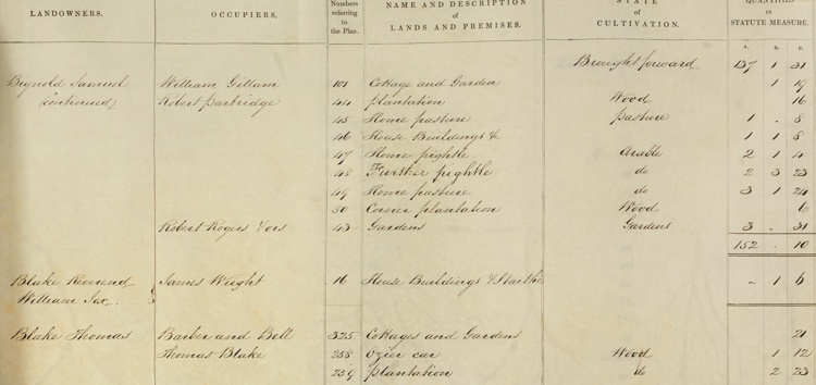
What are Tithe Maps and Apportionments?
Tithe maps and their apportionments were created in the late 1830s and 1840s and were created for over 95% of rural Norfolk. More information about tithe maps and their apportionments is available online. As well as being an invaluable resource for family historians, tithe apportionments give clues to the natural and historical environment through the plot names. For example, a plot called ‘Ozier car’, indicates the land was a fen or bog grown up with willows, whilst ‘dove house meadow’ suggests a building of that description once existed in the vicinity.
All personal data as defined by UK data protection legislation will be retained for the purpose of planning and delivering the Hall Marks project and will not be passed to any-third party without obtaining appropriate permissions. All personal data will be handled in accordance with the Norfolk Record Office’s privacy notice.


I did an in depth study of the Tithe document for Martham some years ago and prepared a map showing who owned all the land at the tiem the Act and another map showing how the land was used. I would be delighted to share my work with the NRO.
LikeLike
Hi Ann, That would be amazing, thank you! Could you email jonathan.draper@norfolk.gov.uk so he can liaise about how to get the information across to him. Thank you once again.
LikeLike
Dear Victoria,
In 1999 I did a project on the Tithe Commutation Act of 1851 in Martham. At the time I was attending Local history Research Classes tutored by Nesta Evans at Wensum Lodge. it is typewritten but not on my computer, so I could photocopy it and send it to you.
LikeLike
Hi Ann,
Thank you very much for your offer. I suspect we would need a digital copy but please email jonathan.draper@norfolk.gov.uk who will be able to let you know. Many thanks.
LikeLike
I wondered when the Tithe map for Cawston was going to have the missing portion,that showing the centre of the village in larger scale,was going to be put back on line.Without it it us very difficult to link the properties to the Apportionment book.
I did a transcription of the Apportionment book well over 10 years ago which I am willing to share, but really regret the fact that the most relevant part if the map is no longer on line.
LikeLike
Hi,
Thanks for getting in touch with us. I will speak to our Partnership and Development Manager about the missing portion of the tithe map.
LikeLike