What were they for?
Tithes are a one-tenth tax paid to religious institutions. Nowadays, some denominations will require them, but they used to be a compulsory part of life for everyone. Prior to the Protestant Reformation, these were paid to local Catholic churches and clergy. However, the land itself came with the right to claim tithes, so some landowners who gained land after the dissolution of the monasteries received tithes alongside the Church of England. Tithes were generally controversial among those outside mainstream denominations, and groups like the Quakers have a long history of refusing to pay tithes.
Tithes were originally paid ‘in kind’ through goods and agricultural produce, rather than money – this is why large tithe barns exist across the country. By the 1800s, this form of payment was inconvenient, unwieldy, and unpopular. Some local areas or individuals had already organised ways to pay the tithes with money, rather than goods, but the 1836 Tithe Commutation Act aimed to standardise this and convert (‘commute’) all tithes into monetary value, called the rentcharge. To do this, Tithe Surveys were conducted at the parish level across England and Wales, covering all the areas where tithes needed to be commuted, as well as some areas where they had already been commuted. Because surveys were paid for by major landowners, they can vary a lot in quality, between those who wanted to show off their land, and those who wanted to spend as little as possible.
These surveys created maps of a parish or smaller area, and apportionments, which ‘apportion’ the land, providing the names of the landowner and occupier, the size of each plot of land, the way it was used (as pasture for animals, or arable land for crops), and the amount of rentcharge for that land. The rentcharge calculations were tied to the price of wheat, barley and oats, and were collected by the landowner on behalf of the Church. Surveys took place between 1837 and 1851, but most were completed in Norfolk between 1838-1842.
At least three copies were usually made: the tithe commissioner’s original (now at The National Archives), the diocesan copy – for different parts of Norfolk, this could be the Diocese of Ely or Norwich (now held by NRO) – and the parish copy (many of these are also held by NRO). Norfolk is one of the areas with the highest coverage of tithe surveys, where almost every parish was mapped, apportioned, and commuted.
Apportionments could be updated or altered over the years, to update who was liable for the rentcharges – sometimes you will find edits between occupiers and owners between the original and the copies made a year or two later! Tithes remained controversial, especially as the fewer people were part of the Anglican church. Rentcharges were abolished in 1936, and tithe payments to the government were phased out over the next few decades (officially ending in 1977).
What do they look like?
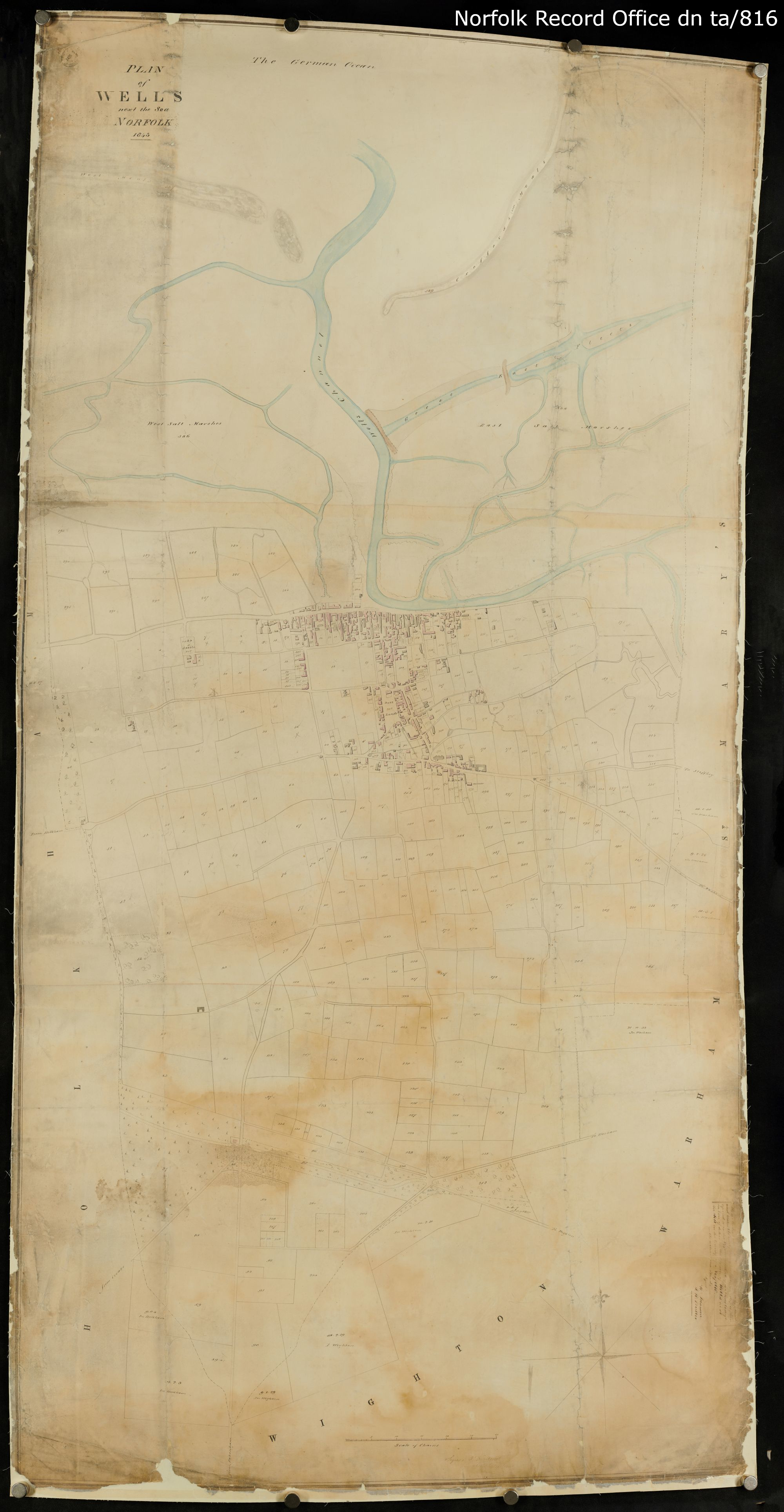
To show you what an apportionment look like, here’s Wells-next-the-sea, which goes with the map above. Plot numbers in this document match up with the numbers on the map.
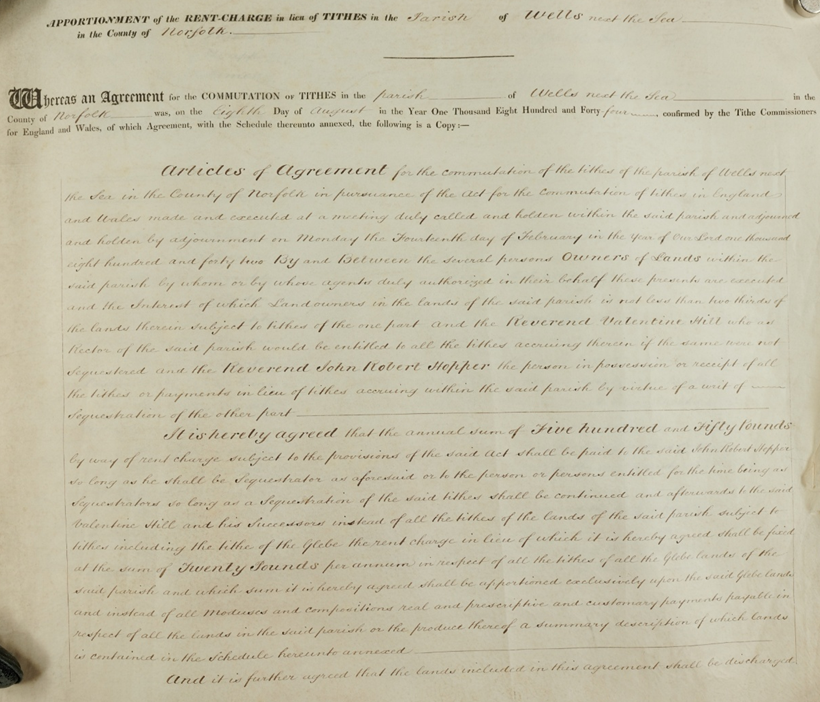
Every apportionment starts with a full copy of the legal declaration of the tithe agreement, but the most interesting part is the front page. Here, it will say when the agreement is made (in this case, 1844) and will sometimes have a stamp to say when this copy was made. 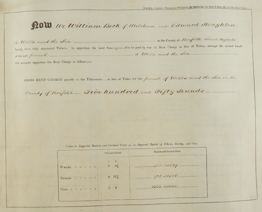
At the end of the introduction we see the major signatories of this, the total rentcharge for the parish (£550) and the prices of grains which were used in calculating rentcharges 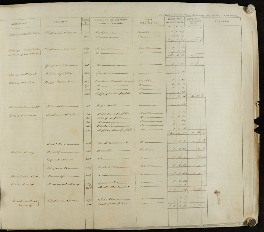
This is a typical page of an apportionment, which are usually organised alphabetically by landowner. Plot numbers relate back to the map, and all have a name – but some surveyors were quite lazy with these! The size of a plot was calculated with very old measures, where acres are divided into rods (or roods) and perches, these perches are surveyors tools, literally measuring sticks. Here, 40 (square) perches (25.29 metres squared) is equal to 1 (square) rod (1011.6 metres squared), and four rods makes an acre. 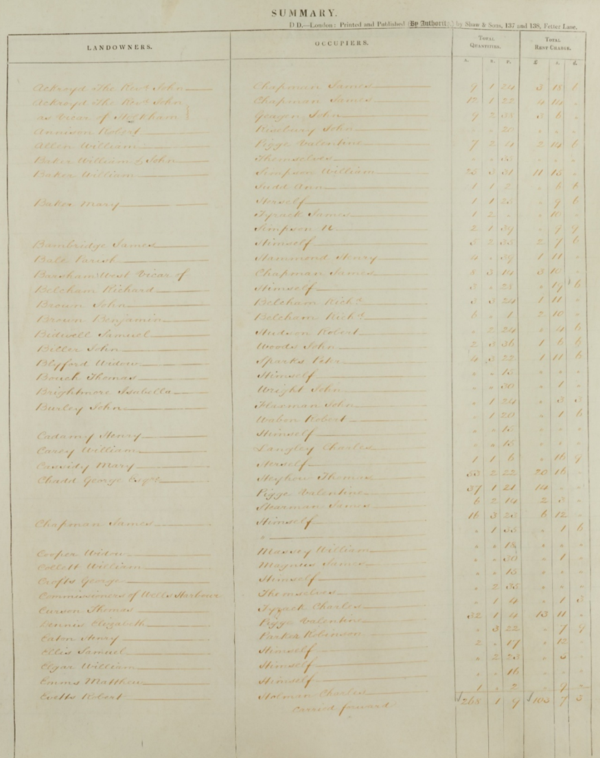
At the end, there is an overall summary, which can be broken down by occupier or landowner, with the overall size of land and rentcharge 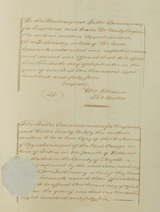
Signed and stamped! 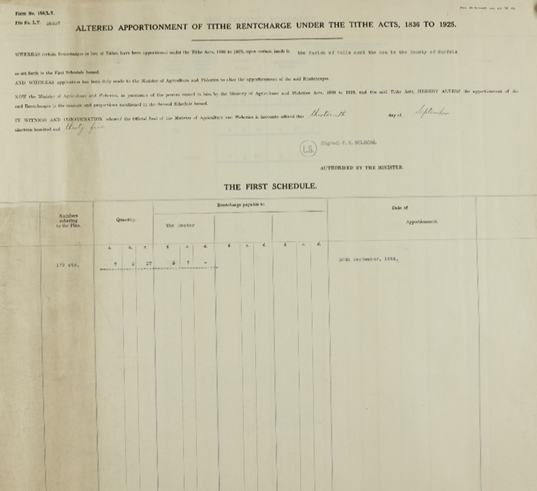
Maps and apportionments are stored rolled together, and you will sometimes find later documents with them, like altered apportionments where certain land ownership has changed significantly, or redemption certificates for the early 1900s. Hall Marks will not be transcribing these, but you can always request to see the map and apportionment at the Norfolk Record Office searchroom, and you might get a surprise like this! 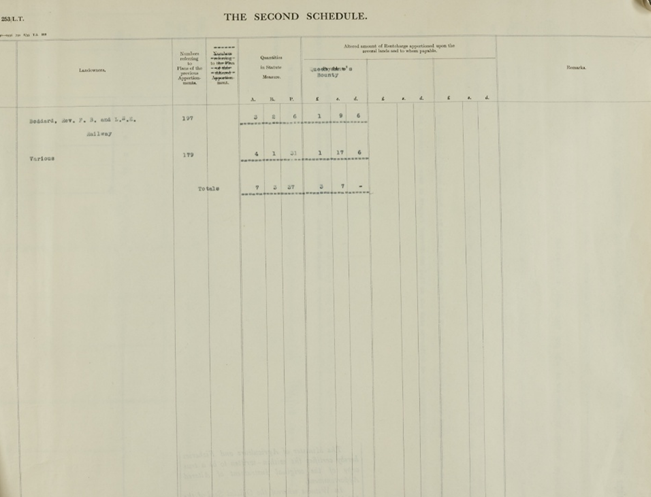
Maps and apportionments are stored rolled together, and you will sometimes find later documents with them, like altered apportionments where certain land ownership has changed significantly, or redemption certificates for the early 1900s. Hall Marks will not be transcribing these, but you can always request to see the map and apportionment at the Norfolk Record Office searchroom, and you might get a surprise like this! 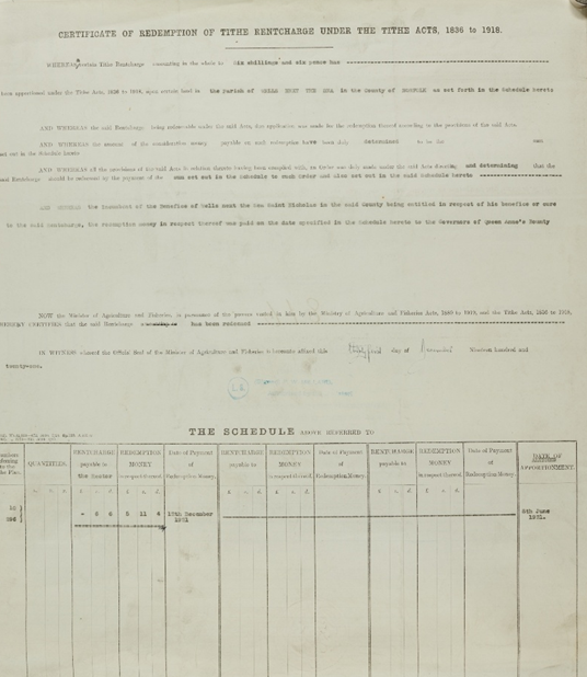
Maps and apportionments are stored rolled together, and you will sometimes find later documents with them, like altered apportionments where certain land ownership has changed significantly, or redemption certificates (ending the tithe payments) from the early 1900s. Hall Marks will not be transcribing these, but you can always request to see the map and apportionment at the Norfolk Record Office searchroom, and you might get a surprise like this!
Why are they interesting now?
This economic history might seem a bit esoteric to many of us, and most people are interested in them for a very different reason now: family history.
Apportionments give more insight into ancestors’ living circumstances, conducted around the same time as the first detailed census in 1841. The maps can also show you the exact buildings your family lived in (occupied buildings were colour-coded red), as well as the plots they worked. The maps can also be very interesting for tracing the history of your house or changes to the landscape. For researchers, this data can also be used as part of investigations of economic and social histories, e.g. comparing the wealth of different parishes, the number of women landowners, or analysing the shifting work of the working class over time.
Hall Marks is working on transcribing the information from apportionments and uploading them to our catalogue – all 700 of them! – to allow anyone to search for family names and find their ancestors’ details. We are also going to be revamping the Norfolk Historic Map Explorer, filling in gaps in the tithe map coverage, and linking each parish to these catalogue details. There will be lots of other map layers on the Explorer, allowing you to compare a point on an 1840s tithe map to the maps from the 1900s and the present-day.
Alongside the regular blogposts from our volunteers and collaborators on the project, we will also update you with progress maps for the map digitisation process and the tithe transcription process – so keep an eye out here or our social media for more frequent updates on whether your parish’s details are available! Or, if you want to get involved and help transcribe the apportionments yourself, you can volunteer to do so online or in-person. You can find out more and express your interest by emailing hallmarks@norfolk.gov.uk.
Hall Marks is made possible with The National Lottery Heritage Fund, thanks to National Lottery players. Thanks also to NAHRG and NorAH for their support.